Daftar Sekarang - Limited 10 Seats Only!

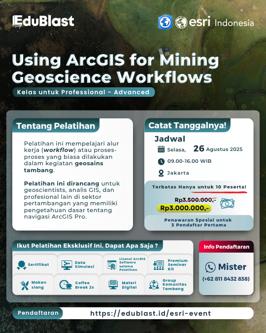
Using ArcGIS for Mining Geoscience Workflows

Advanced for Professional - Class

Mining Economics Workshop
4
Training Lesson
1
Day Intensive
100%
Hands-on Exercise

About The Training

This course introduces ArcGIS workflows that support efficient mining geoscience processes. In course exercises, you will work with realistic mining data to solve problems related to mineral exploration, land management, and mine operations. This course is designed for geoscientists, GIS analysts, and other professionals in the mining sector with basic knowledge of ArcGIS Pro navigation.

What You'll Learn

Explore the core modules of our training program

Lesson 1

  • Store and organize mining data in geodatabase
  • Set up geodatabase behavior for data control
  • Hands-on exercise

Lesson 2

  • Perform spatial analysis on geological maps
  • Convert raw data into surface layers
  • Hands-on exercise

Lesson 3

  • Spatial statistics to reveal trends and clustering
  • Identify mineral hotspots and distribution trends
  • Hands-on exercise

Lesson 4

  • How to design map layout for reports
  • Share your results using ArcGIS workflows
  • Hands-on exercise

Meet Your Trainers

Learn from industry experts with years of practical experience

Belyana

Esri Indonesia

Associate GIS Training Specialist

Ready to Enhance Your Skills?

Secure your spot today for this exclusive training opportunity

Event Details

  • Date: Tuesday, 26 August 2025

  • Time: 09:00 - 16:00 WIB

  • Location: Jakarta

  • Training Fee: Rp 3.000.000,- per participant

What's Included

  • Certificate
  • Simulation Data
  • ArcGIS Software License during the training
  • Digital Materi
  • Premium Seminar Kit
  • Lunch
  • Coffee Break 2x
  • Mining Community Group
Hubungi via WhatsApp